All You Need To Know About Hurricanes: AKA Tropical Cyclones
Hurricanes are named and identified through an international system coordinated by the World Meteorological Organization (WMO). Information was used from the linked website and also the National Hurricane Center, referenced below.
WMO Headquarters is located in Geneva, Switzerland, headed by the United Nations Secretariat. There is a Board of Directors that meet monthly, to discuss the progress of the organizations objectives and goals. WMO works with 193 states and territories across the world. The Organization plays a leading role in international efforts to monitor and protect from the climate and the environment, in particular to weather, climate and water.
The Different Terminologies
Different terminology is used for this weather phenomenon depending on the location:
- In the Caribbean Sea, the Gulf of Mexico, the North Atlantic Ocean and the eastern and central North Pacific Ocean, it is called “hurricane“
- In the western North Pacific, it is called “typhoon“
- In the Bay of Bengal and Arabian Sea, it is called “cyclone“
- In western South Pacific and southeast Indian Ocean, it is called “severe tropical cyclone”
- In the southwest Indian Ocean, it is called “tropical cyclone”.
Here’s an overview of how hurricanes are named and identified:
Naming Hurricanes:
What’s in a Name?
-
- Historically, storms were named, but usually after the fact, and based on a person or object or location.
-
- For example, an Atlantic storm that ripped the mast off a boat named Antje would become known as Antje’s hurricane.
-
- Using female names for storms started in the middle of the 20th century. Then, in the pursuit of a more organized system, meteorologists in the North Atlantic decided to identify storms using names from an alphabetical list.
- As of 1953, the National Hurricane Center provided the name lists for Atlantic tropical storms.
- In 1979, male names were introduced, alternating with the female names.
- Historically, storms were named, but usually after the fact, and based on a person or object or location.
Names are retired if a hurricane is particularly deadly or costly.
-
- WMO has now developed strict procedures to determine a list of tropical cyclone names. There are different rules for naming cyclones in different parts of the world.
-
- In some places like the Atlantic and Southern Hemisphere, cyclones are named alphabetically, alternating men’s and women’s names.
- In other regions, names follow the alphabetical order of the countries.
-
- WMO has now developed strict procedures to determine a list of tropical cyclone names. There are different rules for naming cyclones in different parts of the world.
Naming tropical cyclones has proven to be the fastest way to communicate warnings and raise public awareness and preparedness. Assigning names to tropical cyclones makes tracking and discussing specific storms more straightforward, especially when multiple storms are active simultaneously. Additionally, naming tropical cyclones can aid historical record-keeping and research on storm behavior and impacts.
The Process of Naming Tropical Cyclones
The WMO has a running list of 6 years worth of names, which cycle through every 6 years. Ex: The first Hurricane of 2024 in the Atlantic region will be named Alberto, and then again in 2030 the first Hurricane of 2030 will be named Alberto (of course so long as Alberto doesn’t pose a dangerous threat his first time, eliminating him from the list).
The National Hurricane Center provides a lengthy list of the the names, in which I will portray with just one sample list:

When selecting a new name should a name have been stricken or removed, the WMO go through a set process, using some the following consideration:
- Short in character length for ease of use in communication
- Easy to pronounce
- Appropriate significance in different languages
- Uniqueness – same names cannot be used in other regions.
Identifying Hurricanes:
Formation: Step by Step Explanation
- Hurricanes require warm ocean water as their primary energy source. Sea surface temperatures of at least 26.5 degrees Celsius (80 degrees Fahrenheit) or higher are necessary for the initial development and intensification of a hurricane.
- The atmosphere above the warm ocean water must be unstable, allowing warm, moist air near the surface to rise rapidly. This process is crucial for the formation of powerful updrafts.
- The Coriolis effect, caused by the rotation of the Earth, is necessary for the development of the initial spin or rotation of a tropical cyclone.
-
- The Coriolis effect is weak near the equator, so hurricanes do not form within about 5 degrees of latitude from it.
-
- A pre-existing weather disturbance, such as a cluster of thunderstorms, is needed to initiate the formation of a hurricane.
-
- As warm air over the ocean surface rises, it creates an area of low pressure at the surface.
-
- When the weather disturbance becomes more organized and the winds around the low-pressure center strengthen, a tropical depression can form (less than 60mph wind speeds).
- If the tropical depression intensifies, with sustained winds reaching or exceeding 60mph, it is upgraded to a tropical storm.
- The storm is given a name at this stage, according to the rotating list of names for the specific region, as explained above.
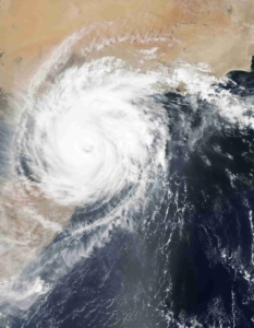
Categorizing Hurricanes:
- The hurricane is categorized into different levels (Category 1 to Category 5) based on its sustained wind speed, according to the Saffir-Simpson Hurricane Wind Scale.
- One of the most dangerous aspects of a hurricane making landfall is the storm surge. This is a rapid rise in sea level caused by the hurricane’s winds pushing water toward the shore.
- Storm surge can result in coastal flooding, inundating low-lying areas and causing significant damage to coastal infrastructure.
- Hurricanes bring extremely strong winds, and when they make landfall, these winds can cause widespread damage to buildings, trees, power lines, and other structures.
- Hurricanes are associated with heavy rainfall, which can lead to flash floods, river flooding, land or mud slides.
- Landfalling hurricanes can spawn tornadoes, adding an additional threat to affected regions.
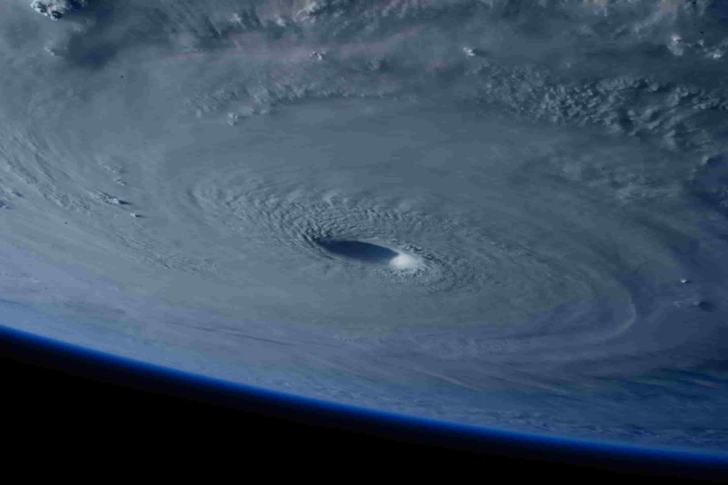
Eye Formation:
- Mature hurricanes typically have a well-defined center known as the eye, which is surrounded by a eyewall which is where much there is much heat formed, and this heat is what fuels the storm
- The eye is often calm, with clear skies.
- The diameter of the eye can vary widely, from a few kilometers to more than 100 kilometers (60 miles) in large hurricanes. (A hurricane can be as wide overall as big as 200-500kms, even bigger has been known to occur.)
- Smaller eyes are often associated with more intense hurricanes.
- In summary, the calmness of the eye is a result of descending air, centrifugal force, low pressure, conservation of angular momentum, and the heat release in the surrounding eyewall. The unique combination of these factors (kind of magically if you ask me) creates a relatively tranquil and clear center within the turbulent environment of a tropical cyclone.
Hurricanes are Sustained by Warm Water:
- The hurricane’s strength and intensity are sustained by the warm ocean water, as long as the storm remains over these warm waters.
It’s important to note that not all tropical disturbances develop into hurricanes, and the conditions described above are necessary but not always sufficient. The complex interplay of atmospheric and oceanic conditions influences the formation and intensification of hurricanes.
Public Alerts: Stay Informed
- When a hurricane poses a threat to coastal areas, public alerts and warnings are issued through various channels, including television, radio, and emergency notification systems.
- Evacuation orders may be issued to ensure the safety of residents in the hurricane’s path.
Hurricane Preparation:
- Emergency Kit: Prepare an emergency kit – view our article detailing this further.
- Evacuation Plan: Know your evacuation routes and follow evacuation orders if issued. See our article about how to create your own evacuation plan.
- Secure Property: Secure windows and doors with storm shutters or plywood. Move outdoor furniture, vehicles, and other items indoors or to a secure location.
- Protect Important Documents: Safeguard important documents such as identification, insurance policies, and medical records in waterproof containers.
- Emergency Shelter: If staying at home is not safe, seek shelter in designated evacuation centers.
- Stay Indoors During the Storm: Once the hurricane arrives, stay indoors and away from windows. Be prepared for power outages, and use flashlights instead of candles.
- After the Storm: Wait for official clearance before returning home or venturing outdoors. Be cautious of hazards such as flooded areas, downed power lines, and debris.
In Canada we are not as affected by Hurricanes, however they can happen! And, if you are a world-traveler by nature, it is important to know and educate oneself about how and when these storms are common around our glorious coastal world.

